
In this new part of our alumni interview series, we talked to Md. Sarfaraz Gani Adnan, who completed our master in 2014 and went on to complete his PhD at the University of Oxford. Adnan tells us about his research projects and how our program and his internship at the GFZ German Research Centre for Geosciences set him on the path to an academic career in disaster risk reduction and urban planning, and spatial sciences, and in particular the effectiveness of different flood interventions in the coastal region of his native Bangladesh.
 Name: Md. Sarfaraz Gani Adnan
Nationality: Bangladeshi
Year of Graduation from Program: 2013/2014
Internship placement: GFZ German Research Centre for Geosciences
Current Occupation: Researcher, School of Geography and the Environment, University of Oxford
Location: United Kingdom
Area of interest/specialty: Disaster Risk Management; Spatial Sciences; Urban Planning
You graduated in 2014 from the Mundus Urbano program and undertook your second year with us. You worked as an Assistant Professor in the Department of Urban and Regional Planning of Chittagong University of Engineering and Technology in Bangladesh until October 2016. You have since enrolled in the School of Geography and the Environment at the University of Oxford and been awarded a PhD. Your research aims to evaluate the effectiveness of alternative coastal flood interventions in the context of Bangladesh. Tell us a bit more about this work.
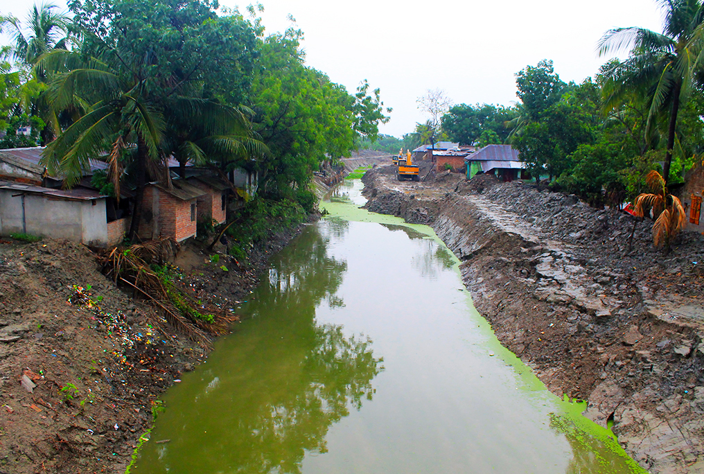
The title of my doctoral thesis is “The legacy of polders: Diagnosing complex flooding processes and adaptation options in the coastal region of Bangladesh”. Polders (enclosed coastal embankments), a form of flood intervention, are often constructed to protect river and coastal floodplains in deltas. Following the Dutch model, a total of 139 polders have been constructed in Bangladesh between the 1960s and 1980s to safeguard agricultural lands from potential damage due to tidal floods, storm surge floods, and salinity intrusion. Whilst such flood control measures reduce the probability of flooding, they have had complex impacts on geomorphological andhydrological processes with consequence for human wellbeing. This legacy of interventions in the coastal system and subsequent human adaptations, now makes decision making even more challenging at a time of increasing environmental pressures.
My doctoral research aims to diagnose complex flooding processes and adaptation options, to assess the effectiveness of different flood interventions in the coastal region of Bangladesh. This research primarily addresses challenges related to the complexities in (i) coastal flood processes, (ii) flood risk assessment, and (iii) estimating the impacts of potential future flood adaptation options. To address the first challenge, this research evaluates the impacts of coastal embankments , creating polders, in Bangladesh on the frequency and extent of inundations caused by different types of flooding. The second challenge has been addressed by analysing land use change dynamics and societal impacts of flooding in a flood risk study. Finally, the potentials of Tidal River Management (TRM) for flood alleviation has been analysed. TRM, an option of temporary ‘de-poldering’, has been tested in some low-lying areas of coastal Bangladesh to help partially recover from the lack of sediment deposition, land subsidence, channel siltation, and salinity intrusion.
By analysing complex coastal flood processes and adaptation options spatially and quantitatively, this thesis provides new evidence to the effectiveness of the past (polders), and potential future (TRM) adaptation options. It also presents a new approach to flood risk estimation, considering the societal impacts of flooding. The results of this thesis could be of importance both in research and practice for making scientifically informed decisions on coastal flood risk management, particularly in Bangladesh.
 Before joining our Master’s program, you studied Urban and Regional Planning in Bangladesh and also taught at university. What made you decide to enrol in our program and in what ways did the Mundus Urbano program influence your professional life?
My research interests include disaster risk reduction, urban planning, and spatial sciences. The desire to explore deeper into these subject areas persuaded me to apply for the Mundus Urbano program. The joint master program in International Cooperation and Urban Development at the Technische Universität Darmstadt (TUD) of Germany and International Cooperation: Sustainable Emergency Architecture at UIC Barcelona in Spain provided me with a unique opportunity to commence a career in research and experience the excitement and satisfaction of being at the forefront of these vast expanding fields. Particularly, at the UIC, the provision of an internship at an internationally recognized organization motivated me to enrol in the Sustainable Emergency Architecture program.
I did my internship at the GFZ German Research Centre for Geosciences, which is the national research centre for Earth sciences, and a renowned organization to conduct research on natural hazards. During the internship, I worked in a BMBF-funded research project WISDOM II – A German – Vietnamese initiative. The research was related to flood risk reduction at the Mekong River Delta of Vietnam. My internship research in the GFZ motivated me to work on disaster risk reduction approaches of coastal delta cities for my M. Sc. Thesis. My M.Sc. research later helped me to get admission at the University of Oxford for pursuing Doctor of Philosophy (DPhil) in Geography and the Environment degree.
 Climate change adaptation and environmental justice are among the core issues of our program. This year our students went on their field trip to Peru, where in March 2017 the natural phenomenon known as ‘El Niño costero’ caused intense rains, and flooding – mainly due to lack of planning – along all of the Peruvian coast. We believe that to tackle these issues, our students need to be provided with the necessary theoretical and methodological background. How do you think architectural and planning professionals – both in the Global North and South – can address urgent emergency topics such as climate change and building resilience?
Flood management, particularly, in the coastal region in active delta systems is a challenging task. There are many examples of unsuccessful flood management schemes in the world. In my opinion, scientific knowledge on the geomorphological, meteorological, hydrological, and anthropogenic environments of the region under study is the key to the formulation of effective flood risk reduction plans. Together, a combination of local knowledge with scientific understanding can help to identify the range of interventions that are likely to alleviate climate change-induced flood risk. Finally, engaging multiple stakeholders including public bodies from plan preparation to implementation phases would advance the implementation of various risk-reducing options.
 What’s coming next for you?
I also hold the position of an Assistant Professor in the Department of Urban and Regional Planning of Chittagong University of Engineering and Technology, Bangladesh. I intend to apply the knowledge attained from my Doctoral research for the development of disaster risk management plans in Bangladesh. Being an academician, I do not want to confine my research area within one country or region. I have already collaborated with various researchers around the world, with an aim to carry out research on various areas of my interests.
Last, but not least, a question we ask all our alumni: What advice would you give to our students or anyone interested in a similar career path?
Those who want to develop a career in academia, first, need to have interests in research. The internship opportunity that the UIC offers can enable students to conduct research in reputed research organizations. Students need to grab this opportunity and start building their research career from there, as I have done.
All photos: Courtesy Md. Sarfaraz Gani Adnan