Assessing the inclusivity of public spaces in Barcelona.
Thoughts on the Master on International Cooperation and Sustainable Emergency Architecture (MICSEA) 2023-2024 Social-Spatial Workshop.
Each year, the MICSEA students engage in a Social-Spatial Workshop at the end of the first trimester which teaches them a methodological and practical approach through a real project in Barcelona. This academic year’s Social-Spatial Workshop, Who is the city for? Assessing the inclusivity of public spaces in Barcelona, focused on the challenges of inclusivity regarding migrant women.
Unlike previous editions, this year the master has not partnered with a local organisation, but instead, director Carmen Mendoza Arroyo along with professor Apen Ruiz and Phd researcher Sara Elthoky have tailored a program without the guidance and constraints that come from other organisations. The workshop gained an in-depth knowledge from the participation of Sara Elthoky, as her research is on Gender and Migration analysing the degree of inclusion of Syrian refugees in European cities.
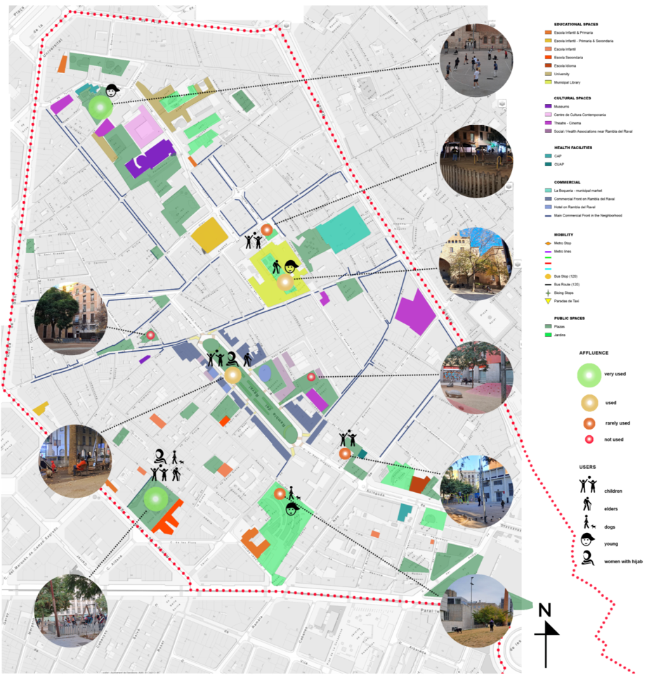
The workshop started by dividing the students in three groups, each focusing on a public space in the following locations: Rambla del Raval (1955), Jardinets de Sants (2016) and Superilla de Sant Antoni (2022). Each of these locations are part of a specific urban intervention, conceived during a specific time and context, responding to planning trends or plans implemented in each particular neighborhood.
The Social-Spatial Workshop uses quantitative and qualitative methodologies and is structured in the following phases:
1- First approach and understanding of the area and subject of study: this phase can include from walks to bibliographical research.
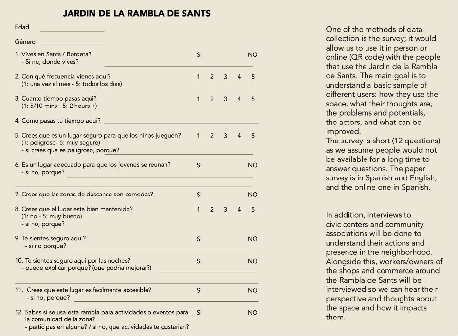
2- Data compilation: interviews, surveys, mapping, etc. with locals as well as demographic data collection.
3- Data visualisation: evolution of the results of the previous phase in visual maps and diagrams.
4- Data analysis: understanding the obtained results, and draft of the first conclusions.
5- Final conclusions and recommendations: based on their study, students are able to draw a series of desirable goals to improve the inclusivity of the public space they analysed.
Group 1: RAMBLA DEL RAVAL
Khaled Hammoud, Serafina Merola, Vana Pistoftzian, Akhila Poojar, Stella Vakalopoulou.
La Rambla del Raval of Barcelona is a short boulevard in the neighbourhood of Raval built in the 1950s with the purpose to organise the narrow and chaotic urban fabric in the old core of Barcelona. The Rambla del Raval is the epicenter of many activities with a diverse demography and close to the touristic areas of Ciutat vella. A priori, this group had to face the bigger challenge when understanding the location they were given. Raval is a complex neighbourhood, and the Rambla is the oldest urban intervention of the three analysed by this year’s students, and has been evolving over time. Nevertheless, students had the support of documents like ‘Pla de Barris’ and testimonials like Andreu Meixide, architect at the city council and coordinator of the document, which were of great help to understand the location. Conclusions included suggestions based on their qualitative research and observations to better the inclusivity regarding the Parks and Mobility.
“(…) we propose a raised crosswalk to reduce obstacles for wheelchair users and people who use strollers or carts when moving around the city.” Quote from students report.
Other insightful remarks from students included how some women were intimidated at answering the surveys when men they knew approached.
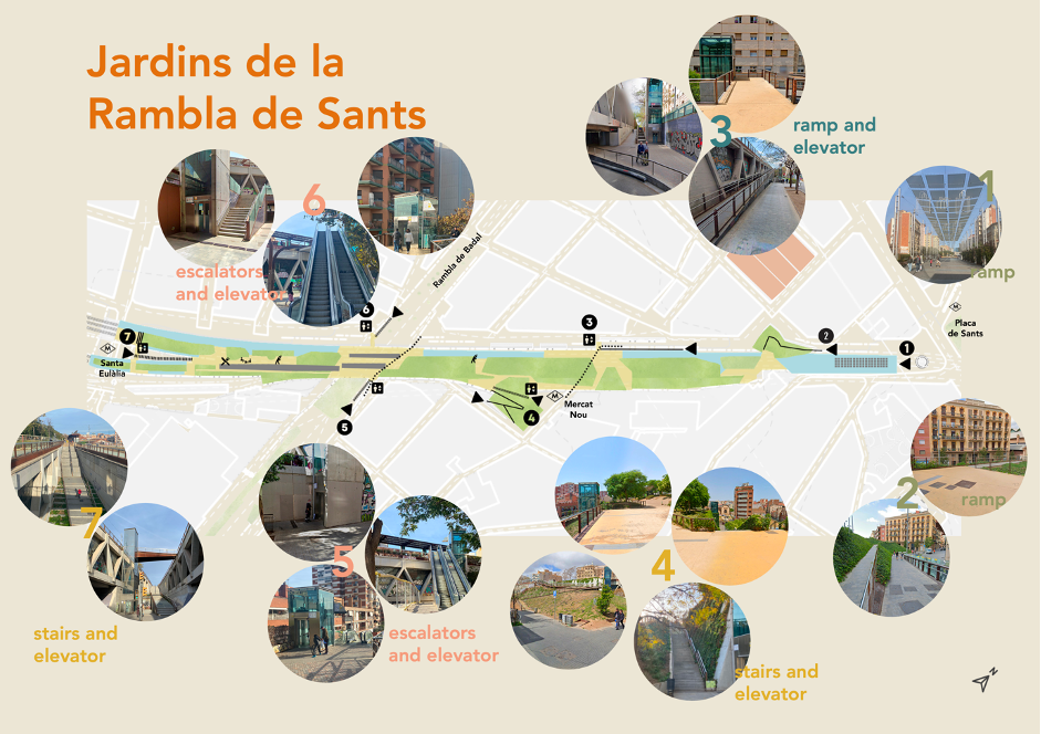
Group 2: JARDINETS DE SANTS
Elisabetta Gravina, Sarah Huber, Louise Ripper, Vittoria Rocci, Cintia Vieira.
Jardinets de Sants is an open-air park located in the neighbourhood of Sants, on the roof of a railroad track, the intervention is inspired by projects such as the New York Highline and Paris’s Promenade Plantée. One of the main characteristics of Sants is that it remains one of the least gentrified neighourhoods in the city, whilst most of Barcelona is being affected by increasing tourism and gentrification. Seeing the architectural characteristics of the Jardinets as an elevated pathway, accessibility was one of the first concerns they had when approaching their location. However, it turned out to be quite accessible, as people that were interviewed expressed there were enough ramps and elevators. The group in Sants used interactive methods, which they described in their report as “the “me gusta / no me gusta” panel as an interactive way to collect data. The panel was put beside a sticker map so people could write down what they like and dislike about the place – being as general or specific as they wanted. This helped the group gather a good understanding of what people think about the spaces of la Rambla de Sants.”
Conclusions again focused on security in terms of lighting, artificial at night and shade during the day, as well as community engagement and large green areas. Insightful remarks included the surprising number of women compared to men enjoying the space and the large amount of complaints around hygiene and dogs.
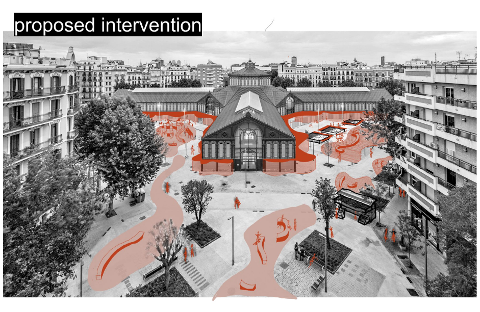
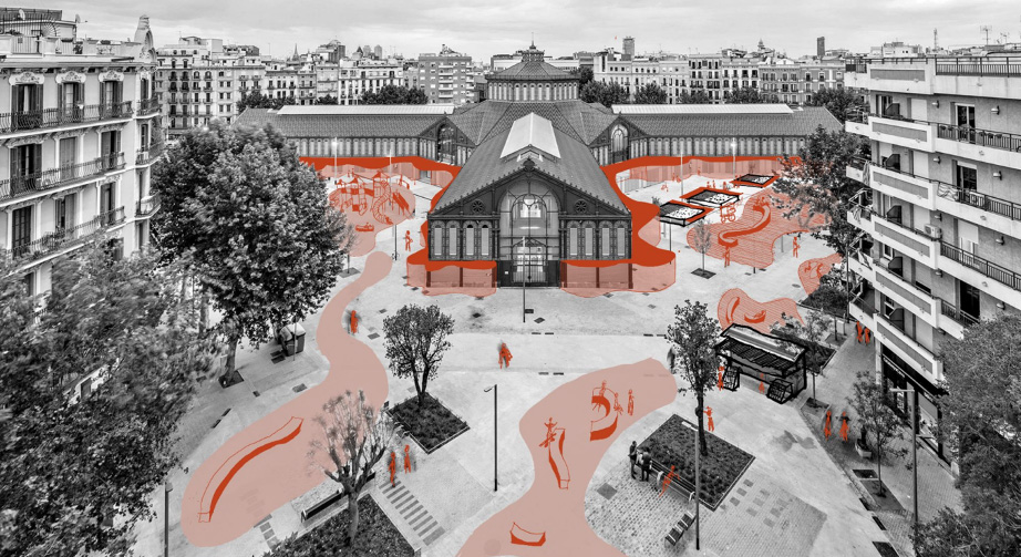
Group 3: SUPERILLA DE SANT ANTONI
Amelie Colsman, Amy Ferrer Rogers, Laura Vasconcelos, Luzgélik Delgado, Farah Aisyah Mior.
The superilla of Sant Antoni is a recent urban intervention, part of the Mobility Plan of Barcelona and which aims to pacify the often tough grid of the Eixample of Barcelona. In this case, the location is in the border between Raval and the Eixample. The superblock of Sant Antoni includes the public market of Sant Antoni, around which students mainly focused their analysis. In this site, students were positively surprised by the change of use of the public space throughout the day: the morning, with the expected activity around a market and in the afternoon, with younger people enjoying dance classes, meeting with friends and skateboarding.
“The square under Sant Antoni Market provides many opportunities for these activities; however, this is directly related to a noticeable increase in noise and music. In this context, many interviewed elderly individuals indicated that it is uncomfortable for them and makes them feel insecure” (quote from the Final Report by the group in Sant Antoni).
Again, conclusions from the Superilla of Sant Antoni insisted on community interaction and the recommendation of activating the market’s surroundings.
CONCLUSIONS
As the three locations had different characteristics, conclusions in each were also diverse. For instance, conclusions in Raval focused on security, mobility, and parking; in Sants they focused on dog management, incrementing night lighting and community engagement. In Sant Antoni they also focused on community engagement, spaces that promote social interaction, and the connection between the public realm and the market’s interior. Despite the differences, the recommendations for all the three locations were to increase the amount of green space and improve liveability and community engagement. All three open spaces analysed this year had positive aspects that help create inclusive spaces for migrant women. With the recommendations of our students, we can go one step further to creating truly inclusive urban spaces that take everyone’s needs into account and foster social interaction and integration.